Archived on 6/5/2022

Where is SE23 exactly anyway?

thirstforwine
14 Jun '16

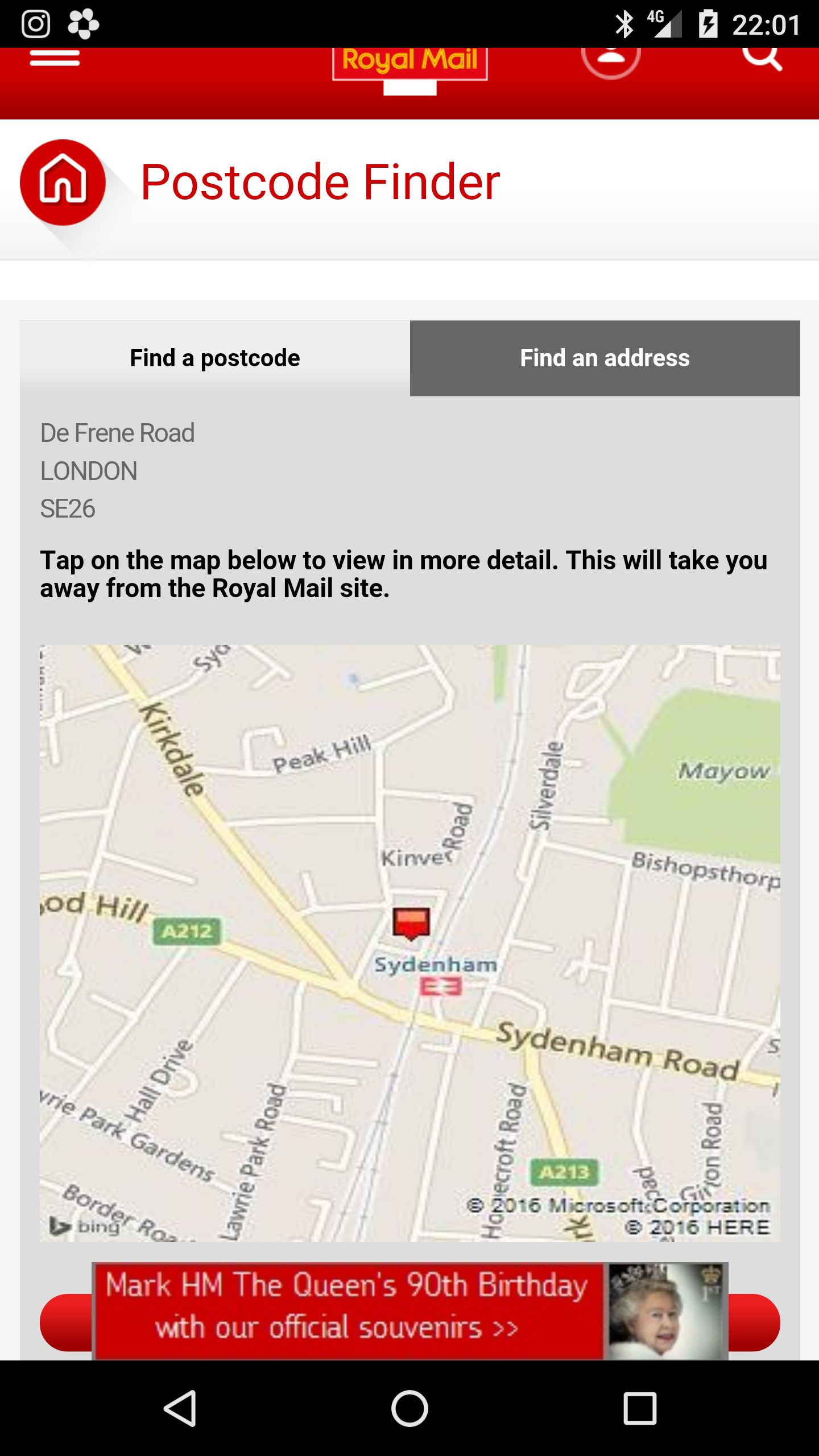
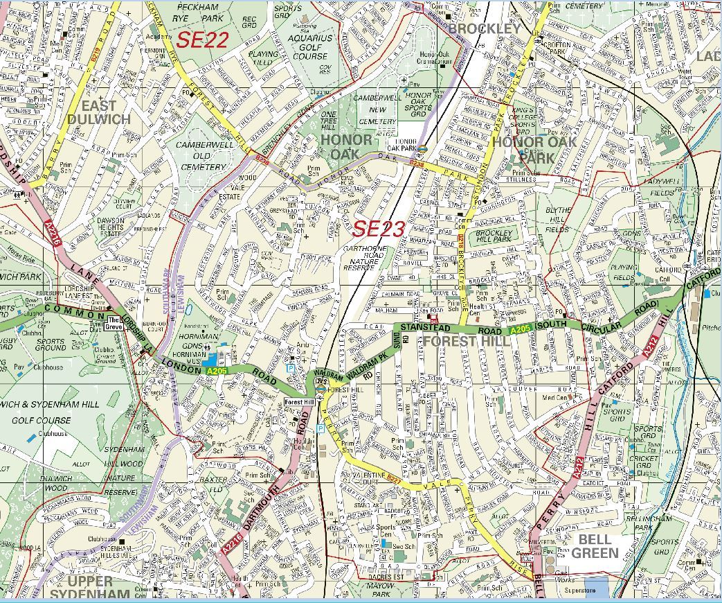
I was trying define the area covered by the name “SE23” and I’m struggling to find the official boundaries.

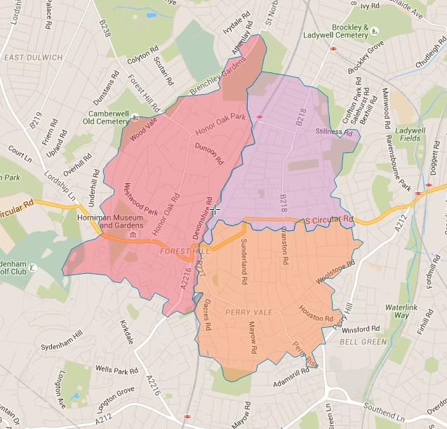
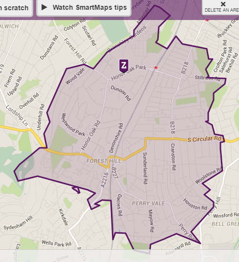
I came across the issue in the past and created my own map back in 2007, but I assumed it would be easy enough to do with the latest map resources. Sadly they don’t seem to agree. Does include De Frene Road? What about portions of Mayow Park? What about the side roads off Dacres Road, and even Dacres Road Nature Reserve itself?

Here, for example, are two rather different lines for the southern boundary aroundDacres Road; the first from Google Maps, the second from Postcodearea.co.uk

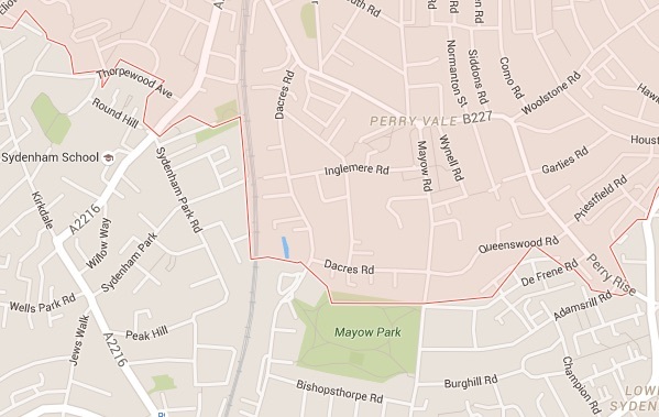
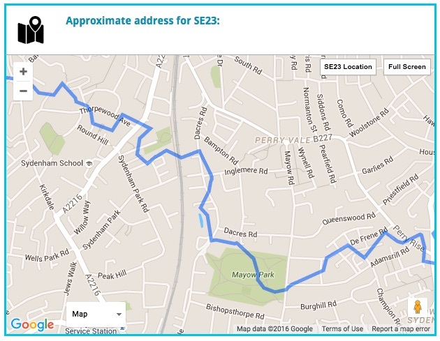
Anyone know, or can point me to an official map?

anon64893700
14 Jun '16

I would assume Royal Mail have the definitive answer to that one, but finding a map is something else.
Postcode finder would help show any splits on roads.

anon64893700
14 Jun '16

De Frene, apparently not.

RachaelDunlop
14 Jun '16

Mayow Park is in SE26. I believe the high-rise flats on the north edge of the park are SE23. North of the mini-roundabout at Dacres Road is definitely SE23.

thirstforwine
14 Jun '16

This looks reasonably authoritative

MajaHilton
14 Jun '16

What may be confusing to some is how our Council Ward boundaries do not go via post codes. In our case SE23 is in 3 different wards and only one of those is referred as Forest Hill Ward. Then part of upper Sydenham is in Forest Hill ward too.

I attach the link for your interest. https://www.google.com/maps/d/viewer?mid=148BmtW2s2VQjf5JC-MA7rMU0lQo&hl=en_US

(Vested interest declared in my profile)

simonk133
14 Jun '16

You can produce postcode maps on Zoopla, like so:

(do a search for a postcode then click ‘map view’ on the results page)

thirstforwine
14 Jun '16

thanks @simonk133 but that too appears to be an approximation (straight lines are a give-away), however, it matches the Google map version on ‘freemaptools’ which I’m hoping is the most accurate in this instance - or at least accurate enough for my purposes I guess

cheers!

simonk133
15 Jun '16

If you want more precision, Ordnance Survey have downloadable postcode maps. See https://www.ordnancesurvey.co.uk/business-and-government/products/code-point-with-polygons.html

They are GIS compatable but I think also convertible to xml (Google earth)

Londondrz
15 Jun '16

@Simonk Yes, I have a large wall mounted map from Of maps giving SE23 boundaries.

Brett
15 Jun '16

There is no precise answer to this as green spaces tend not to have delivery addresses. Regardless, am compelled to ask @thirstforwine: to what end do you want to define this?

thirstforwine
15 Jun '16

well, for one, since this is “SE23 LIFE” i thought it might be nice to have some idea of what SE23 actually is

however, I have ulterior motives to do with my walking (hence the old blog which I am trying to think of ways to revive in an interesting way) and I thought that it might be easier to work out what those boundaries were this time around

More will be revealed in due course!

Londondrz
15 Jun '16

Hope this helps https://www.ordnancesurvey.co.uk/election-maps/gb/

Brett
15 Jun '16

@thirstforwine yes that is fine but as a community forum I would suggest that there is no need to be precise about it. Bear in mind that Honor Oak is not all in SE23 for instance.

thirstforwine
15 Jun '16

I’m not threatening anyone with expulsion :wink:

but we have adopted the SE23 moniker, and yet it seems hard to define … and thought it might throw up interesting questions and discoveries (such as sections of roads that are on the edge, why they are one postcode or other, possibly depending on when they were built, etc.)

however, I have a more specific, personal reason which will become clearer soon.

Brett
15 Jun '16

This isn’t about expulsion, rather inclusion. Postcodes are not very good at defining communities IMO and is only hard to define if used to define an area as that is not what they are designed to do! As for this site adopting it, well that is just the name of the site as far as I am concerned. :slight_smile:

thirstforwine
15 Jun '16

Well, if it puts your mind at ease over community inclusion, I’m only planning some walking routes and just needed to know which bits are IN or OUT

:slight_smile:

anon64893700
15 Jun '16

Oh don’t start this IN / OUT lark lol

Jon_Robinson
15 Jun '16

post code areas are/were defined by Royal Mail. They’re all 7 characters long, the first four are outbound (designating which sorting office to go to first, the last 3 inbound, designating which round from there. In Greater London the central area is all x1 so N1, E1, SE1, SW1 EC1, etc. after that they’re done alphabetically by regional area, which is why SE16 is next to SE1, and SE26 and SE23 are next to each other - problem is that I don’t know the regional areas used for the codes. I think that SE16 is Rotherhithe. New areas are added at the end - so E20 was supposed to be Walford (as in Eastenders), but has now become the new Olympic Park area in Stratford.
as postal district areas are based on address points then it can be a bit arbitrary where you draw a line between two houses on opposit sides of a road with differing codes, if done automatically you get something like the google image…
if anyone has access to Bartholemews maps of London they include post code boundary lines. not that great detail but you get the idea.

anon64893700
15 Jun '16

After reading that @Jon_Robinson I have just realised we have huge postcode maps at work, doh lol.

thirstforwine
15 Jun '16

that’s GREAT thanks - I didn’t know about them and assumed some authoritative map must exist

hopefully I can use this to create my walks. Thanks so much

appletree
16 Jun '16

I never know what to say when asked where we live. Technically it is SE26 but in Forest Hill Ward, and we see Forest Hill centre as more our shopping/restaurant area rather than Sydenham. I had occasion to write to the police team for Sydenham and was told I should have written to Forest Hill’s. Confusing.

Brett
16 Jun '16

Then be happy with saying Forest Hill. Postcodes determine who delivers your post. :slight_smile:

Michael
16 Jun '16

Just to be a little pedantic (that is the point of this thread, isn’t it?) SE23 includes tiny sections of an additional two wards in Southwark; College and Peckham Rye.

appletree
16 Jun '16

Thanks. A nice area, whatever you call it.